PROMOTIONS AND OFFERS
Discounts on multiple DJI, EMLID and Pix4D products

We offer all kinds of technical solutions for companies and individuals. We advise you and inform you of everything.

Sale!
Secure payment Secure payment
Shipping in 24/48 h. Shipping in 24/48h
Technical advice Technical advice

Pix4Dsurvey

From: 190,00

Pix4Dsurvey

PIX4Dsurvey is the new PIX4d software, the meeting point between photogrammetry and CAD.

Work and vectorize over any point cloud to create CAD files.

Jess Gregory
Jess Gregory
2022-08-22
Excellent software for processing drone images, excellent communication, nice people! Thank you so much. Highly recommend their software!
Razib Ahmed
Razib Ahmed
2022-08-22
Great team with experienced professionals. I experienced quick response from the technical support team eventhough I was not their customer. Thank you Fede A and your team.
Esteban Laffitte
Esteban Laffitte
2021-12-19
Gran equipo de profesionales, siempre dispuestos a aclarar cualquier duda tanto en la pre como en la post-venta. Enhorabuena por el servicio qué ofreceis y la calidad de los productos que vendeis.
JOSÉ ANTONIO MARTÍNEZ SÁNCHEZ
2021-12-17
He colaborado con ellos, son muy profesionales y muy recomendables.
Jose Maria Marin Poley
2021-09-23
Hasta ahora todo correcto y rápido.
Maxi Diaz
Maxi Diaz
2021-09-15
La atención al cliente ha sido excelente. Envío a Canarias sin complicación. Recomendado.

Pix4Dsurvey, the tool to transform your point cloud into CAD planes

Pix4Dsurvey is the new tool created by PIX4D to convert a point cloud into CAD planes. It is the meeting point between photogrammetry and CAD.

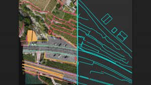
Extract unique elements in 3D

Integrated solution
pix4survey
Working with multiple point clouds
Pix4Dsurvey integrates into your existing workflow. With just one click, import .p4d files generated with Pix4Dmapper or work with LAS files.
Amplify your ability to work
Pix4Dsurvey can process billions of points. Work with multiple point cloud files at the same time and in the same project.
Get even more data
When desired, use Pix4D rayCloud to simultaneously access the original 3D point clouds and images. With Pix4Dsurvey you can analyze even complex objects such as catenary only visible in images.
Integration of vectorization and digitization tools

pix4dsurvey road brands

Vectorize your project using points, polylines, polygons, and catenary in just a few clicks.
Easy export
pix4dsurvey exports cad
Each analyzed object can be assigned to a layer for editing. Export your layers together or separately to facilitate the transition to your preferred CAD or GIS program.

What’s the process?

Capture — Model — Vectorize — Integra

Captura

pix4dsurvey catch

Shoot images or point clouds with a drone or with any laser scanner.

Models

pix4dsurvey processes and models

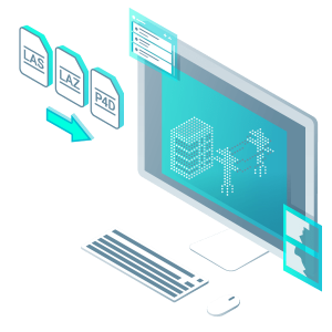
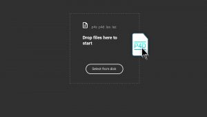
Transform your images into digital point clouds and import them into Pix4Dsurvey. Work directly with PIX4Dmapper files or any .las or .laz file.
You can use our PIX4Dmapper software to obtain a point cloud from data captured by your drone or any other tool that allows you to generate point clouds from images.

Vectoriza

pix4dsurvey digitizes and vectorizes
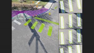
Create engineering-ready CAD files from point cloud data by extracting key elements from your project. Vectorize breaklines, singular elements, and any other highlights.

Integrates

pix4dsurvey integrates

View the data in any CAD or GIS program. Enjoy its simplicity and precision and add custom layers and properties to accommodate your existing workflow.

beyond a point cloud

Extract the most important information to speed up and simplify your workflows.

Vectorice without limits

Harness the combined potential of images and point clouds to extract the most important elements of data obtained by photogrammetry, laser scanning, or LiDAR. Discuss urbanization elements, building plans, walls, catenary, and more.

Flexible and adaptable

Work with large and small projects. Easily treat multiple photogrammetric or laser scanned files simultaneously.

CAD-compatible

Generate vector files with layers and properties that make it easier to transition to CAD or GIS programs without taking up much space.
Valóranos
Menu
AVISO IMPORTANTE

A partir del próximo 06 de abril le atenderemos en nuestras nuevas instalaciones del Malaga Tech Park (antiguo Parque Tecnológico de Andalucía) en calle Marie Curie 3, 1º Planta

×
IMPORTANT

Due to current government measures, we are teleworking.
Therefore, we would ask you to please write us an e-mail at store@atyges.es to tell us about your doubts.
We will reply to you immediately.

×